By Ellalyn De Vera-Ruiz
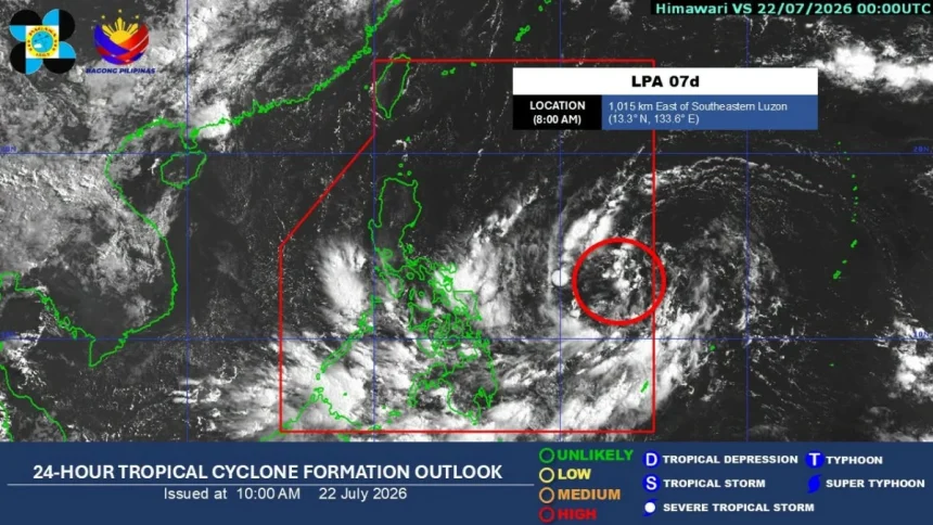
The low-pressure area (LPA) east of southeastern Luzon has a high chance of developing into a tropical depression within the next 24 hours, the Philippine Atmospheric, Geophysical and Astronomical Services Administration (PAGASA) said on Wednesday, July 22.
During the agency’s climate forum, PAGASA weather specialist Loriedin dela Cruz-Galicia said the LPA, designated as LPA 07d, was located 1,115 kilometers east of southeastern Luzon as of 7 a.m. and had entered the Philippine Area of Responsibility (PAR) Wednesday morning.
Once it intensifies into a tropical depression, the weather disturbance will be given the local name “Kiyapo.”
The LPA is expected to move generally west-northwestward and may make a close approach or landfall over Cagayan province between Friday, July 24, and Saturday, July 25.
Dela Cruz-Galicia said the potential cyclone could affect Northern Luzon and parts of Central Luzon regardless of whether it makes landfall.
Based on the latest analysis, the LPA could reach tropical storm strength before its close approach or possible landfall.
Further intensification is possible after it crosses the landmass of Northern Luzon.
Dela Cruz-Galicia said the highest possible wind signal that may be raised is Signal No. 2, although the timing of any wind signal issuance will depend on the development of the weather disturbance.
Meanwhile, she said the southwest monsoon, or “habagat,” continues to affect Palawan and Mindanao and is expected to bring rains over most of Mindanao, Western Visayas, Negros Island Region, Central Visayas, and Palawan.
Scattered rains and thunderstorms may also affect the southern sections of Luzon and eastern sections of the Visayas due to the trough or tail of the LPA.