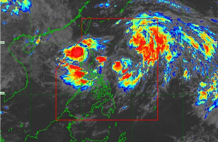
Two tropical cyclones are now within the Philippine Area of Responsibility (PAR).
On Wednesday, July 23, a low-pressure area (LPA) near Northern Luzon intensified into a tropical depression and was named “Emong.” It follows “Dante,” which had already formed off the coast of Aurora on Tuesday, July 22.
As of 11:00 a.m., Emong was located 115 kilometers west-northwest of Laoag City, Ilocos Norte, heading west-southwest at 35 kilometers per hour. It packs maximum sustained winds of 45 kph and gusts of up to 55 kph.
Due to Emong’s anticipated strong winds, PAGASA raised Tropical Cyclone Wind Signal No. 1 over the following areas: Ilocos Norte; Western Ilocos Sur, including Sinait, San Juan, Cabugao, Santo Domingo, Magsingal, Bantay, San Ildefonso, San Vicente, Santa Catalina, City of Vigan, Caoayan, Santa, Narvacan, Santa Maria, San Esteban, Santiago, City of Candon, Santa Lucia, Santa Cruz, and Tagudin.
Also under Signal No.1 are Western La Union, including City of San Fernando, San Juan, Bacnotan, Luna, Balaoan, Bangar, and Bauang; Western Pangasinan, including Dasol, Burgos, Agno, Bani, Bolinao, City of Alaminos, Mabini, and Anda.
PAGASA warned of minimal to minor impacts from strong winds in these areas.
Weather specialist Benison Estareja said that based on the current forecast, Signal No. 2 may be raised as Emong may intensify into a tropical storm by Thursday afternoon or evening, July 24.
Emong was expected to move generally southwestward before looping over the West Philippine Sea on Thursday, due to its interaction with Dante.
Meanwhile, “Dante” (international name: Francisco) intensified into a tropical storm on Wednesday morning.
As of 11 a.m., it was located 900 kilometers east of extreme Northern Luzon, with sustained winds of 65 kph and gusts up to 80 kph. It was moving north-northwest at 15 kph.
Although Dante is not expected to make landfall, its position is favorable for enhancing the southwest monsoon or habagat, which, along with Emong, is expected to bring persistent rainfall over much of Luzon and parts of the Visayas until Friday.
PAGASA also noted another LPA outside the PAR, located 2,340 kilometers east of Eastern Visayas, with a “moderate chance” of developing into a tropical depression within 24 hours. (Ellalyn de Vera-Ruiz)