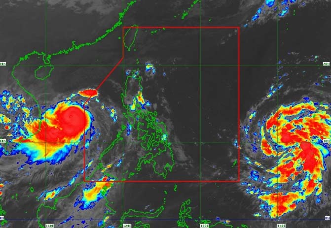
A tropical depression outside the Philippine Area of Responsibility (PAR) has intensified into a tropical storm as Typhoon Tino (Kalmaegi) exited the region, the Philippine Atmospheric, Geophysical and Astronomical Services Administration (PAGASA) said Thursday, Nov. 6.
As of 4 a.m., the center of Tino’s eye was located 265 kilometers north-northwest of Pag-asa Island in Kalayaan, Palawan, moving west-northwestward at 35 kilometers per hour (kph).
The typhoon further intensified over the West Philippine Sea, with maximum sustained winds of 155 kph near the center and gustiness of up to 190 kph.
Only the Kalayaan Islands remain under Tropical Cyclone Wind Signal No. 1, with minimal to minor impacts expected from strong winds.
‘UWAN’ COMING
Meanwhile, the tropical depression outside the PAR intensified into a tropical storm and was given the international name “Fung-wong.”
As of 4 a.m., its location was estimated at 1,715 kilometers east of northeastern Mindanao, moving northwestward at 20 kph, with maximum sustained winds of 65 kph near the center and gusts of up to 80 kph.
PAGASA said Fung-wong may continue moving northwestward until Friday, Nov. 7, before turning west-northwestward.
It is expected to enter the PAR late Friday evening or early Saturday, Nov. 8, where it may rapidly intensify into a typhoon and could reach super typhoon strength by Saturday.
Once inside the PAR, it will be given the local name “Uwan.”
PAGASA warned of potential life-threatening conditions if the storm reaches peak intensity near landfall over Northern or Central Luzon.
It added that wind, rain, and sea conditions are expected to worsen as Fung-wong approaches.
Moderate to rough seas may begin over the northern and eastern seaboards of Luzon and the eastern seaboards of Visayas and Mindanao by Friday or Saturday.
Very rough to phenomenal seas could affect most of Luzon and the eastern seaboards of Southern Luzon and Visayas from Sunday onwards, with gale warnings likely over coastal waters starting Saturday. (Ellalyn Ruiz)