Even as rains and strong winds from Typhoon Tino (Kalmaegi) continue to lash Visayas, the Philippine Atmospheric, Geophysical and Astronomical Services Administration (PAGASA) is already monitoring a new tropical cyclone – set to be named “Uwan” once it enters the Philippine Area of Responsibility (PAR).
PAGASA weather specialist John Manalo said the low-pressure area (LPA) outside the PAR developed into a tropical depression at 8 a.m. on Tuesday, Nov. 4.
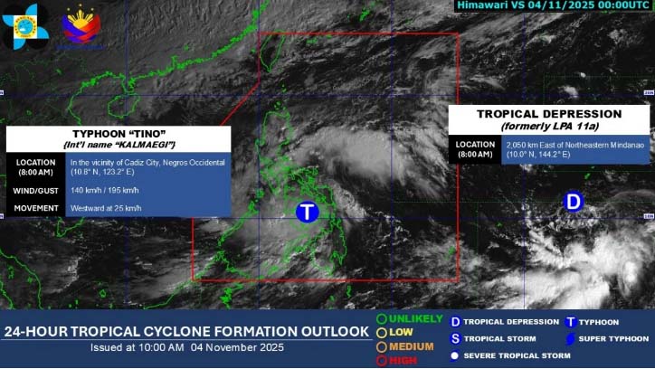
As of 10 a.m., its center was located 1,985 kilometers east of northeastern Mindanao, packing maximum sustained winds of 55 kilometers per hour (kph) near the center and gustiness of up to 70 kph while moving westward at 20 kph.
Once it enters the PAR, the weather disturbance will be given the local name “Uwan.”
Manalo said it may enter between Friday, Nov. 7, and Saturday, Nov. 8, possibly as a typhoon.
“Kaya heads-up po sa ating mga kababayan dahil although medyo may kalayuan pa siya at posible pa magbago ‘yung track nito, gusto po natin i-advance na iinform ang ating mga kababayan patungkol sa tropical depression na ito na muli ay posible makaapekto sa atin lalo na sa darating na weekend ,” Manalo said.
Meanwhile, Typhoon Tino has so far made four landfalls on Tuesday: over Silago, Southern Leyte at 12 a.m.; Borbon, Cebu at 5:10 a.m.; Sagay City, Negros Occidental at 6:40 a.m.; and San Lorenzo, Guimaras at 11:10 a.m.
Manalo said another landfall remains possible over Panay Island before the typhoon moves into the Sulu Sea on its way to northern Palawan by Wednesday morning, Nov. 5.
It may exit the PAR by Thursday, Nov. 6, while continuing to move west-northwestward at 25 kph.
(Ellalyn Ruiz)